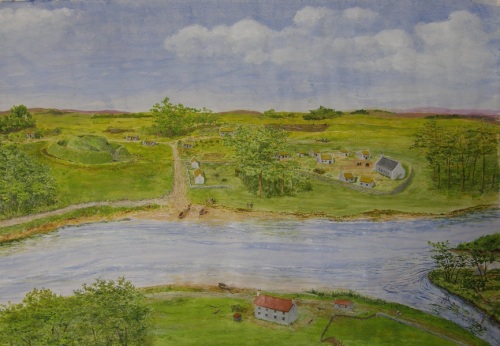
Medieval Govan (Copyright © Donald Watson)
My recent blogpost on the Barochan Cross socket-stone was accompanied by photographs kindly supplied by Donald Watson. Donald has also sent me the above image which represents his own evocation of pre-industrial Govan (c.1500 AD). It is a fascinating picture, not least because it incorporates the four principal features that confirm Govan’s status as a centre of royal power in early medieval times: the old parish church with its carved stones; the Doomster Hill; the ceremonial path of the kings; the ancient crossing-point on the Clyde.
Like Robert Paul’s well-known engraving of 1757, Donald’s picture is a view of Govan from the north side of the river. It gives a clear impression of the relationship between the various natural and man-made features and allows us to imagine how they would have interacted in the ‘ritual landscape’ of the kings of Strathclyde.
The historical significance of Water Row,whose conservation is currently under threat, is immediately apparent from the picture, which highlights the key role played by this ancient thoroughfare in defining the geographical identity of Govan. Water Row is the lane leading down to the river-crossing in the centre of the picture.
* * * * * * *


")

Leave a comment